Sunday, October 31, 2010

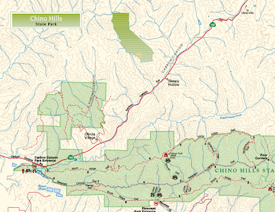
Chino Hills State Park

Chino Hills Sate Park is a unique park that is both biodiversity and solitude to the visitors who enjoy their outdoor experiences. There is no other location in the LA Basin where people can drive a short distance and be swept away with scenic vistas, hike, bike or ride a horse on over 65 miles of trails. 
At 14,102 acres the park is managed as an open space habitat where all plant and animal life are protected.

Chino Hills State Park, a premier natural open-space area in the hills of Santa Ana Canyon near Riverside, is a critical link in the Puente-Chino Hills biological corridor. It encompasses stands of oaks, sycamores and rolling, grassy hills that stretch nearly 31 miles, from the Santa Ana Mountains to the Whittier Hills. Chino Hills is vitally important as a refuge to many species of plants, and as a link between natural areas essential to the survival of many animal species. 

Ranging from 430 feet to 1,781 feet in elevation, the park straddles the north end of the Santa Ana Mountains and the southeast portion of the Puente-Chino Hills, which together form the northern end of the Peninsular Ranges in Southern California. This formation interrupts the generally flat Los Angeles Basin with a variety of rolling hills, mountains and canyons on its south and east sides. The hills are a result of uplift and folding along the Whittier and Chino faults.

For humans relaxing or recreating in the park, Chino Hills is an island of tranquillity in a sea of urbanization. For the plants and animals in the park, Chino Hills is a link to other natural areas. Southern California is so heavily urbanized that it is impossible to preserve the huge tracts of land needed to ensure species diversity. However, by providing a major biological link between islands of open space, Chino Hills effectively makes habitats larger.

Chino Hills is also a place where people can escape the pressures of urban life and find peace and solitude in a natural setting. Visitors can camp for a few days or simply enjoy a walk, horseback or bicycle ride over trails that meander through valleys and along ridge tops through woodlands, sage scrub and grasslands. Sixty miles of trails and fire roads also offer excellent opportunities for viewing wildlife and native plants. Facilities consist of a picnic area, equestrian staging area, pipe corrals, a historic barn, water spigots and restrooms. Most of the trails accept multiple use. However, a few trails are designated for hiking only, because of safety issues or the potential for damage to habitat.

Location - Directions
The park is located 10 miles northwest of Corona. Take the 91-Freeway to Highway 71-North, turn left at Soquel Canyon. Proceed to Elinvar and turn left. Elinvar merges into Sapphire on the left, the park entrance is located on the right.
4721 Sapphire Road; Chino Hills, CA  91709; Latitude/Longitude: 33.9198 / -117.7144

Sunday, October 24, 2010

Malibu Creek State Park

Here is a hike that will not only take you to back to the Vietnam War on the set of M*A*S*H*, but also to where they filmed the television series “Swiss Family Robinson” as well as where they filmed some of the Tarzan movies among other things. 

Before land for Malibu Creek State Park was obtained in 1974, it was divided into three parcels owned by Bob Hope, Ronald Reagan, and 20th Century Fox. Although the park is still used for moviemaking, it’s largely a retreat for day hikers and picnickers.

It’s an easy, nearly level walk that visits a dramatic rock gorge, Century Lake and several locations popular with moviemakers as still seen while hiking.


Filled with gorgeous oak-shaded paths and breathtaking vistas, this hike is surely a repeat on my list.


Directions to trailhead: From Paciļ¬c Coast Highway, turn inland on Malibu Canyon Road and proceed 6.5 miles to the park entrance, 0.25 mile south of Mulholland Highway. If you’re coming from the San Fernando Valley, exit the Ventura Freeway (101) on Las Virgenes Road and 

continue four miles to the park entrance.

To Rock Pool is 3.5 miles round trip with a 150-foot elevation gain.
to Century Lake is 4.5 miles round trip with a 200-foot elevation gain.


Friday, October 15, 2010

Pacific Palisades Hiking Trails.

 Among the hikes in the santa monica mountains as well as
Pacific Palisade trails,Tomescal Canyon is among the most popular for locals. the reason is that this trail is among the esiest around with plenty to see. Temescal Canyon is the quickest way into the wilderness in this area. Hikes here are anywhere from 1-5 miles. you can easily get here by taking Santa Monica to the Pacific Coast Highway north, once you're on the PCH take a right on Temescal Canyon road. You can follow this road until it ends. there will be a gatekeeper at the end to answer your questions about the hike, the plant life and animals who are indigenous to the area. The head of this trail is at the end of the Canyon at the Gateway Park. The hike goes thru a   beautiful waterfall . One can continue to do a full loop around it. this particular trail leads down a View Point Trail which has a beautiful site of the Pacific Ocean. the entire loop of this canyon is 4.4 miles round trip, which is a fairly easy hike and should not take very long to complete.
As i mentioned earlier this is a very popular hike for most people because of the scenery. there is a couple of waterfalls which can be seen just by following some of the trails. this particular waterfall is a nice place for anyone to just sit, rest and catch your breath. The first part of this hike is uphill which gives one lots of opportunities to see some very nice sites. I first went on this hike upon returning from a deployment. i really enjoyed because it is a very relaxing place. there is usually not many people if one goes in the early morning, but since it is very popular it quickly becomes congested. there is a "NO DOG BEYOND THIS POINT" rule but it is not enforced like one would expect. so feel free to take your dog. This trail is also great to take your kids, since it is one of the easier trails in Pacific Palisades.


    over all this is a great hike for most. there are some dangers to this hike. For one, the are plenty of rattle snakes. if you take your family here you should wear hard shoes and always be on the look out for wild snakes. If you look around you will also see plenty of squirrels and maybe some deer.


Finally, the plant life. there is not too many exotic plants 
in this hike, i actually haven't seen any. this area is mostly
surrounded by native gardens, plenty of oak and sycamore trees. 
there is also plenty of poison oak, so if you see it stay away it. 


once again, if you're looking for a nice mellow hike this is the one that i would recommend. it is not a difficult trail, and you will get a chance to see some beautiful sites. my favorite is the site of the Ocean.


contact info:
15601 W Sunset Blvd
Pacific Palisades, CA 90272
310-454-1395


Sunday, October 10, 2010

Aliso & Wood Canyons Wilderness


Aliso & Wood Canyons Regional Park, the largest park in the hills above Laguna Beach, preserves 3,400 acres of pastoral Orange County.
Most locals and other hikers refer to the low hills that back the Orange County coast from Corona del Mar to Dana Point as the Laguna Hills or “the mountains behind Laguna Beach.” Actually, the northerly hills are the San Joaquin Hills, their cousins to the south the Sheep Hills.
Here’s how nature writer Joseph Smeaton Chase described an outing in the Sheep Hills in his classic 1913 book, California Coast Trails: A few miles along a road that wound and dipped over the cliffs brought us by sundown to Aliso Canyon. The walls of the canyon are high hills sprinkled with lichened rock, sprinkled with brush whose prevailing gray is relieved here and there by bosses of olive sumac. Our camp was so attractive that we remained for several days.”


Aliso & Wood Canyons Regional Park is a great place to hike, but it does present a minor access problem: From the parking area to the mouth of Wood Canyon is a less-than-scintillating 1.5 mile walk alongside a road. Some hikers avoid this road walk by bringing their bikes--either mountain bike or standard bicycle will do--and cycling to the “true” trailhead. Cyclists can ride some of the park’s trails (the wider dirt roads), then leave their bikes at conveniently placed racks and walk the narrower, hiker-only paths.

 From the parking area, hike along the paved into Aliso Canyon. The road, and a parallel dirt path for hikers, heads southeast, and meanders just west of Aliso Creek. After 1.5 miles of walking, you’ll arrive at the park’s most significant signed junction (complete with restrooms no less). Join Wood Canyon Trail (a dirt road) and begin a gentle ascent through Wood Canyon. Look left for the side trail leading to Cave Rock, where you’ll find a number of caves, wind-sculpted into a substantial sandstone formation.
 Look left for the side trail leading to Cave Rock, where you’ll find a number of caves, wind-sculpted into a substantial sandstone formation.
After rejoining Wood Canyon Trail, continue up-canyon to another left-branching side trail that leads to Dripping Cave a.k.a. Robbers Cave. The robbers who hid out here in the 19th century included cattle rustlers and highwaymen, who held up stagecoaches. The “Dripping,” much of the year anyway, refers to water seeping above the cave.

 
Wood Canyon Trail continues to meet Mathis Canyon Trail. A short distance up Wood Canyon Trail is an old sheep corral. You can turn around in the vicinity or choose to extend your hike in a couple of different ways.


 If you want to leg it just a little more, head up Mathis Canyon, then north on Coyote Run Trail. Next, fork right to reconnect with Wood Canyon Trail. For a longer loop, bear left on northbound Rock-It Trail and connect with West Ridge Trail.
a junction with Wood Canyon Trail on your right. Join this path (a dirt road) as it begins the very gentle ascent of Wood Canyon. Skirting the base of the Sheep Hills, the path visits the remains of an old corral and delivers the trees promised on the park map--Five Oaks Canyon and Sycamore Grove.

From Sycamore Grove, you can loop back via a trail on the opposite side of Wood Canyon by joining the short connector trail that leads to Coyote Run Trail.
Ambitious hikers will join either Lynx Trail or Cholla Trail (near the end of Wood Canyon Trail), head west over West Ridge Trail, then south to Rock It Trail or Mathis Trail, either of which returns you to Wood Canyon and the way back to the trailhead.


 Directions to trailhead: From the San Diego Freeway in Laguna Hills/Mission Viejo, exit on Alicia Parkway and drive 4 miles south. Trailhead parking for Aliso & Wood Canyons Park is located a quarter-mile south of Aliso Creek Road. Then a right into the parking lot, which is opposite Laguna Niguel Regional Park and near the Orange County Natural History Museum.

Sunday, October 3, 2010

Upper Newport Bay Reserve

   I like to explore the trails of Upper Newport Bay Preserve and Ecological Reserve, both with my camera to capture bird sightings and a journal to take field notes. There’s nothing like fresh scenery to add a little spring to your step and pull time off your mile.


    Several hundred visitors a year walk or cycle along the edge of Upper Newport Bay. But very few hike the trails on the west side of the bay. Upper Newport Bay preserves the bluffs surrounding the bay & offers the hiker a special vantage point for observing one of the most pristine of Southern California’s wetland estuaries.


  The bluffs look down on birds that gather here in large numbers—more than 35,000. The estuary is home to nearly 200 species of birds, including several endangered ones such as the Savannah sparrow; almost exclusively a marsh sparrow that cannot thrive in any other habitats. Three uncommon bird species have spotted by the bluffs, including the burrowing owl, San Diego cactus wren and the California gnatcatcher.


The reserve is a home to a broad spectrum of avian life. 
     Waterfowls in shallow sand consists of Dowitchers, Gray WilletsMarbled Godwits and Long-billed Curlews. The still waters of the bay also harbored, among other birds, Forester's TernsWestern GullsBrown PelicansDouble-crested Cormorants,Pied-billed GrebesAmerican CootsSnowyGreat, Blue herons and Great egrets.


   The duck mix is heavy on - Mallard & American Wigeon  but also  includes Northern Pintail & Ruddy Duck. The raptors are hourly visitors, hovering over the patches of salt grass looking for a delightful snack or meal. They are mostly harriers, vultures, red-tailed hawks, and unmistakable Osprey who is an exclusive fish eater. 


  While the bay nourishes salt water marsh and wetland habitats, the adjacent slopes powered by abundant sunlight lets sage scrub and chaparral flourish. Mash plants are the common ones of any coastal wetland; plants such as Pickle weed, Bull rush, Salt grass, Salt wort and Crystalline ice plant etc.


  However, if one does not want to miss out on the ever green and lush riparian woodland, he or she must find the way to big canyon. Big canyon has it all; Western sycamores, Cottonwoods, Black and Narrow-Leafed willows, Laurel sumacs, White alders, Giant reed and Mule fat. 
The gentle slopes nearby the big canyon trail have scattered patches of Coast prickly pears, Spiny rush, Coast sunflower and California rose. 


   An ecosystem as exquisite as the Upper Newport Bay Nature Preserve and Ecological Reserve demands repeated visits. This is a big deal, considering both the outstanding avifauna this part of California can deliver as well as the other superlative habitats along the stretch of this Bay. Below you will find the   Map of the trail and driving directions. Best time to hike this breathtaking portion of california coast is as early as dawn and stay till dusk to experience ecosystem's diverse forms throughout the day. 


Directions to Trailhead:
From the San Diego Freeway (405) Northbound, take the Jamboree exit and turn Left. Drive a few miles and turn Left again on San Joaquin Hills Rd which will end at the back bay drive. Parking is free along the back bay street. Back bay expands on both sides of the bay edge. Follow the map!


Don't forget to revisit this blog to share  comments about your experience.